 GIScases
GIS & spatial analysis
From the science of the Earth to the map that computes: geography, cartography, geoinformatics — and the GIS.
Geography has travelled a long way from its origins. To the ancients it meant simply describing the known world; today it is a broad family of sciences, constantly enriched by new methods and disciplines. Geography is often treated lightly — filed away among the humanities or the social studies — yet much of it sits squarely among the Earth and natural sciences, concerned with measuring and explaining the planet itself. Among its instruments are cartography and cartography's modern daughter, geoinformatics — and at their sharp end, the geographic information system. This lesson traces that lineage.
Geography: from “earth-writing” to a science of the Earth
The word geography was coined by the Greek scholar Eratosthenes in the 3rd century BCE — Ancient Greek γεωγραφία (geōgraphía), from γῆ (gê, “earth”) and γράφω / -γραφία (gráphō / -graphía, “to write / writing”) — literally “earth-writing”, the description of the world.
That original sense — an inventory of lands, peoples and places — served for two thousand years. Modern geography is far wider and far more analytical.
Modern geography is the science that studies the Earth's surface — its physical and human features, the processes that shape them, and their spatial distribution and interrelations.
It spans two great branches: physical geography — a full Earth science, dealing with landforms, climate, water and ecosystems — and human geography, which reaches into the social sciences. Treating geography as “only” a social subject misses half of it; increasingly, both branches rely on measurement, data and quantitative, spatial methods.
Cartography: the science of the map
For most of history, geography's principal instrument was the map — the way spatial knowledge was recorded, reasoned about and communicated. The discipline of the map is cartography.
Cartography is the discipline dealing with the art, science and technology of making and using maps (International Cartographic Association).
At the centre of cartography stands its product — and a map, in the strict sense, is far more than a picture of a place.
A map is a reduced, generalised and mathematically defined model of the Earth's surface (or part of it), built in a map projection and to a stated scale, so that the position, distance and area of features bear a defined, measurable relationship to reality.
The decisive words are mathematically defined: a map rests on a mathematical basis — a projection (a formula that transfers the curved Earth onto the plane), a fixed scale, and an underlying geodetic coordinate framework. Because of this, a map is not merely looked at but measured; in this sense it is a metric model of reality. (The International Cartographic Association captures the communicative side of the same idea — “a symbolised representation of geographical reality … designed for use when spatial relationships are of primary relevance”.)
Making a true map is therefore at once craft and science: choosing a projection, designing symbols, and generalising detail so the essential stands out — decisions that determine what the map can and cannot tell you.
Geoinformatics: cartography's modern daughter
When computers arrived, the map stopped being only something we draw and became something we compute. Storing the world as data — and analysing it — gave rise to a new discipline.
Geoinformatics is the science and technology that develops and applies methods for capturing, storing, processing, analysing and presenting spatially referenced information.
It is the modern, computational branch of the geographic sciences — cartography's daughter — drawing on geodesy, remote sensing, photogrammetry, and computer and information science. Its most familiar working tool is the GIS.
The geographic information system
A geographic information system (GIS) is an organised system of hardware, software, data, methods and people for capturing, storing, managing, analysing and presenting information that is tied to locations on the Earth's surface.
In everyday use, “GIS” often names the application software — an electronic map editor. In the academic sense it means something more specific: an information system built around a concrete body of geodata about a particular object or territory. One speaks of “the GIS of the Black Sea” or “the GIS of the Burgundy vineyards” — each a distinct system with its own data, methods and purpose. The software is merely the tool; a GIS proper is the working system assembled around real data.
Within geoinformatics, then, a GIS is where data, methods and people come together to do the work. Two ideas make it powerful. First, every record carries where it is — its location, or geometry — and what it is — its attributes. A river is stored both as a line on the ground and as a row of properties. Joining the “where” to the “what” is what separates a GIS from an ordinary map (location, but no data behind it) and from an ordinary database (data, but no sense of location).
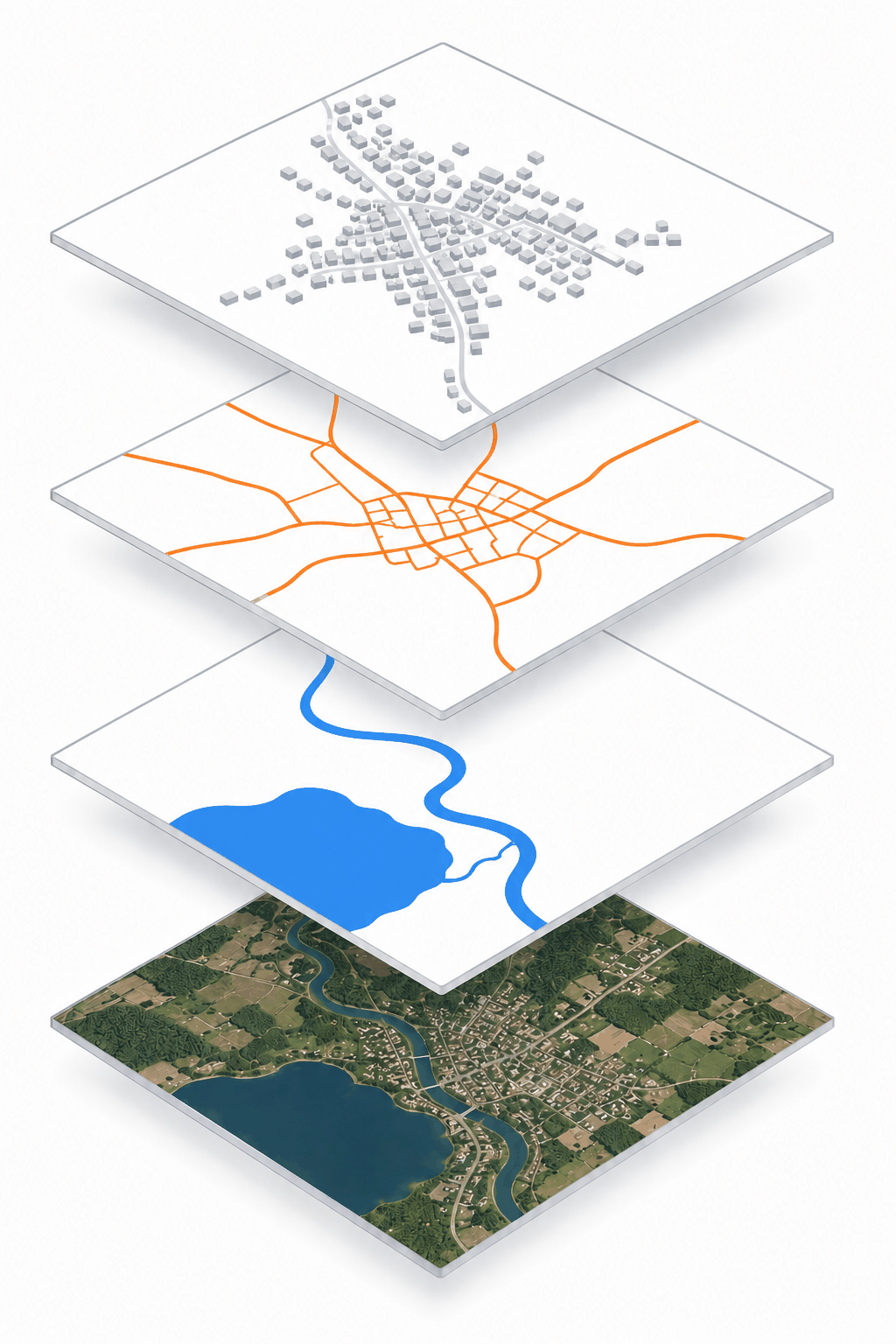
Second, a GIS represents reality as a set of thematic layers registered to the same ground — roads, water, buildings, land use, elevation. Because they share a common coordinate framework, the layers line up and can be overlaid, compared and combined. That layered model is the foundation of all analysis.
What is spatial analysis?
Spatial analysis is the set of techniques that examine the locations, attributes and relationships of features to answer questions and produce new information — information not obvious from the raw data.
It is what turns a map from a picture into an instrument of reasoning. Typical questions a GIS is asked:
- Location — where is a feature, and what is there?
- Proximity — what lies within (or beyond) a given distance of something?
- Density — where are features most and least concentrated?
- Containment — what falls inside a given area?
- Relationships and patterns — how do features relate to one another spatially?
- Change — how has an area changed over time?
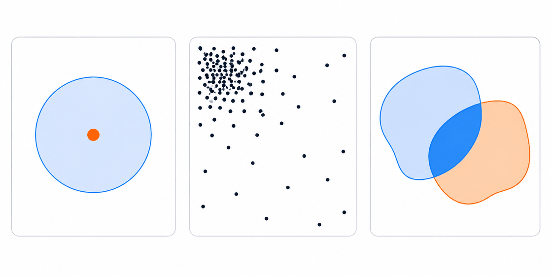
The power comes from combining geometry and attributes across layers. Not merely “here is a school”, but “which ground lies within 500 m of a school and away from a main road” — a question that draws on several layers at once. Answering questions like these is the essence of every GIScase.
System, science — and where this leads
The letters GIS carry more than one meaning: Geographic Information System for the technology, and Geographic Information Science (GIScience) for the discipline that studies the concepts beneath it. This analytical, data-driven turn is exactly what has moved modern cartography beyond static maps and made geography a quantitative science.
The rest of this series builds the toolkit one idea at a time — coordinates, scale, the spatial primitives, thematic layers, buffer zones, and the overlay operations that combine them into a site-suitability analysis. That is the reasoning behind every case you will build and solve in GIScases.
A closing word: this is far from the whole of what a modern GIS can do. Remote sensing, three-dimensional and terrain analysis, networks and routing, spatial statistics, real-time and web mapping — much lies beyond these pages. Our aim here is narrower: to set out a few basic principles and possibilities, enough to give a working sense of how the technology is used. Across the series you will meet the core concepts of GIS and, through GIScases's engaging cases and the tools of this site, be ready to put spatial analysis into practice yourself.
What you’ll learn in this lesson
- Geography began as “earth-writing” (Eratosthenes) and is today a broad science of the Earth's surface — physical (a natural science) and human — not merely a social subject.
- Cartography is the discipline of making and using maps; geoinformatics is its modern, computational daughter — the science and technology of spatially referenced information.
- A GIS is the working system of geoinformatics: it stores each feature as both a location (where) and attributes (what), and models reality as registered thematic layers.
- Spatial analysis derives new information from those locations, attributes and relationships — proximity, density, overlay, change — turning a map into a reasoning tool.
- “GIS” names both a technology (System) and a discipline (Science) — the heart of modern, analytical cartography and geography.
References
- de Smith, M.J., Goodchild, M.F. and Longley, P.A. (2018) Geospatial Analysis: A Comprehensive Guide to Principles, Techniques and Software Tools. 6th edn. Edinburgh: The Winchelsea Press.
- Gimond, M. (2023) Intro to GIS and Spatial Analysis. Available at: https://mgimond.github.io/Spatial/ (Accessed: July 2026).
- International Cartographic Association (2003) Mission and definition of cartography. Available at: https://icaci.org/mission/ (Accessed: July 2026).
- Konecny, G. (2003) Geoinformation: Remote Sensing, Photogrammetry and Geographic Information Systems. London: Taylor & Francis.
- Kraak, M.-J. and Ormeling, F. (2020) Cartography: Visualization of Geospatial Data. 4th edn. Boca Raton, FL: CRC Press.
- Longley, P.A., Goodchild, M.F., Maguire, D.J. and Rhind, D.W. (2015) Geographic Information Science and Systems. 4th edn. Hoboken, NJ: Wiley.
- Robinson, A.H., Morrison, J.L., Muehrcke, P.C., Kimerling, A.J. and Guptill, S.C. (1995) Elements of Cartography. 6th edn. New York: Wiley.
- National Geographic Society (2023) Geographic Information System (GIS). Available at: https://education.nationalgeographic.org/resource/geographic-information-system-gis/ (Accessed: July 2026).
 Made by Solebo
GIScases · Learn — free to use in your classroom.